Whether you are an experienced hiker looking to traverse the highest mountains in Hokkaido or a nature lover looking for a relaxing walk away from the bustle of Sapporo, there is something for all levels. I hope this post will help you decide which is the best hiking trail in Hokkaido for you.
What are the best hiking trails in Hokkaido?
Activity Guide
By Richard
With acres of untouched wilderness and mountains rich with flora and fauna, the island of Hokkaido in the north of Japan is a hiker’s paradise. A vast network of hiking trails climb over volcanic mountain peaks, around caldera lakes and along wild coastlines.
Being able to pop out for an afternoon hike up a volcano or spend a night out on the roof of Hokkaido is one of the reasons I choose to call Hokkaido home.
Hokkaido’s best hikes – chosen by Adventure Hokkaido guide Richard
Here are my favourite hikes in Hokkaido, click on the links to go straight to the trail you’re most interested in or scroll down to read the whole article.
Nakadake Onsen #
- Time: Day hike / 5-6 hours
- Distance: 10km / 320m elevation gain
- Difficulty: 🥾🥾
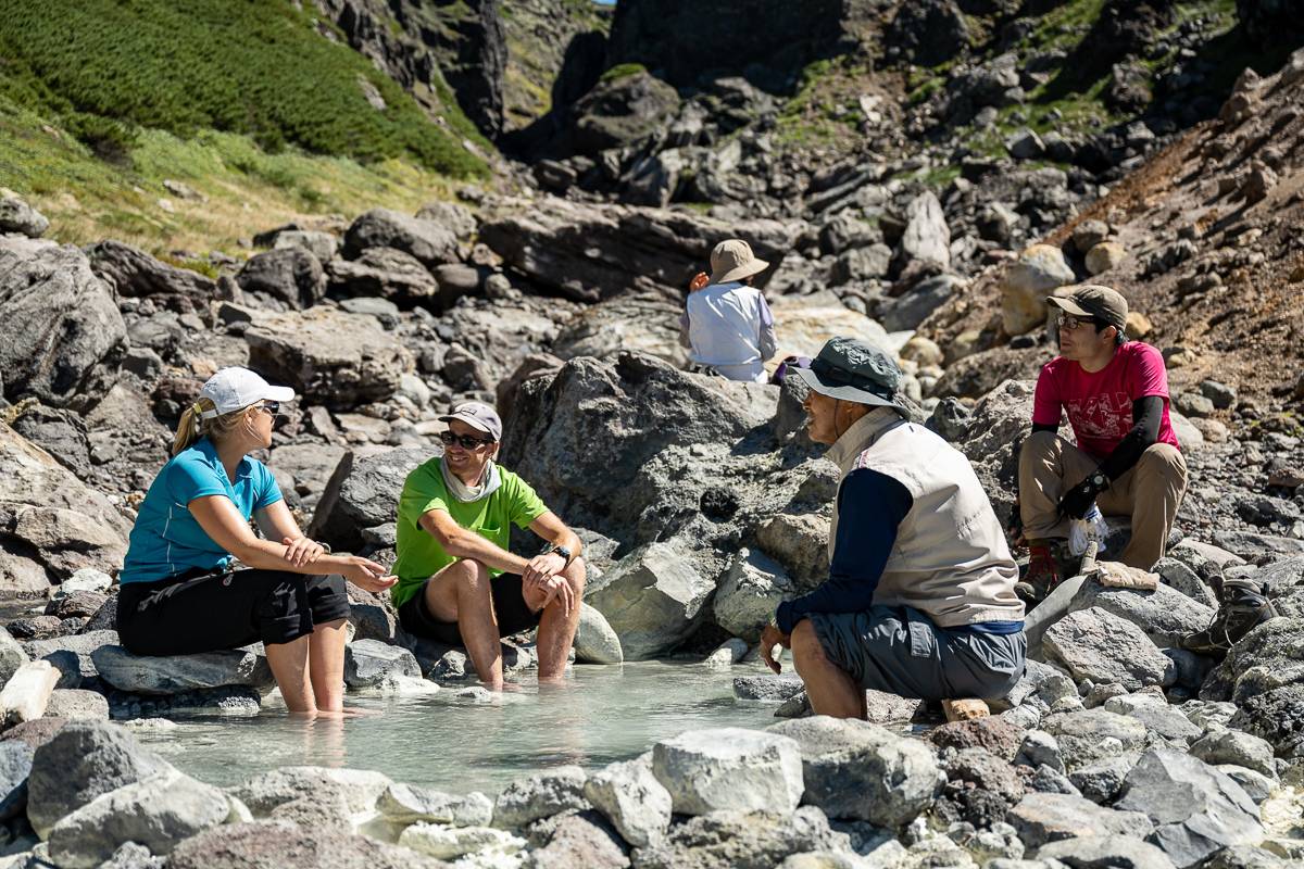
Nestled in the mountains of the Daisetsuzan National Park, Nakadake Onsen (1830m) combines two of my favourite things; mountain landscapes and onsen (natural hot springs). The hot water rises directly out of the ground and mixes with cold stream water in small pools forming a truly natural hot spring.
The 10km return hike from the top of the Asahidake Ropeway passes through tunnels of Haimatsu (Dwarf Siberian pine) and across gullies that hold snow well into summer. It then emerges onto an alpine meadow called Susoai-daira full of alpine flowers, including Aleutian avens with white petals that become wispy cotton as autumn arrives.
What you will see hiking to Nakadake Onsen
- A natural onsen (hot spring) set in a steep rocky gorge.
- An alpine plateau carpeted with flowers and backed by the highest peak in Hokkaido.
- Possibly a bear if you are lucky (or unlucky depending on how close it gets!)
Best time for hiking at Nakadake Onsen
The trail is under snow between November and June. The Aleutian avens bloom between mid-June and July and then turn deep red in September.
Nakadake Onsen Local’s tip
Susoai-daira is bear country. Make sure you have a bear bell and consider carrying bear spray. Get the latest information on bear sightings from the Asahidake Visitor Centre near the base of the ropeway.
How to get to Nakadake Onsen
Nakadake Onsen is just north of Asahidake in central Hokkaido and the trail starts from the top of the Asahidake Ropeway. Asahikawa Denkikidou run a bus service (#66 Ideyu-go) to the ropeway from Asahikawa station via Asahikawa Airport.
Handy locations for hiking Nakadake Onsen
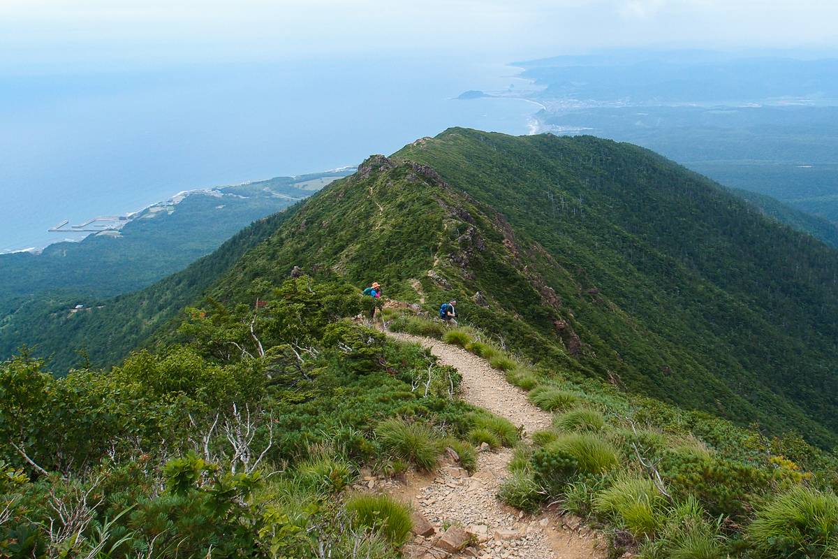
Traverse from Mt Asahidake to Mt Kurodake #
- Time: Overnight or a long day / 8-9 hours
- Distance: 13km / 1010m elevation gain
- Difficulty: 🥾🥾🥾🥾🥾
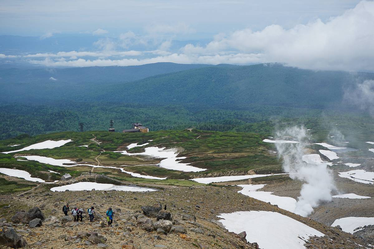
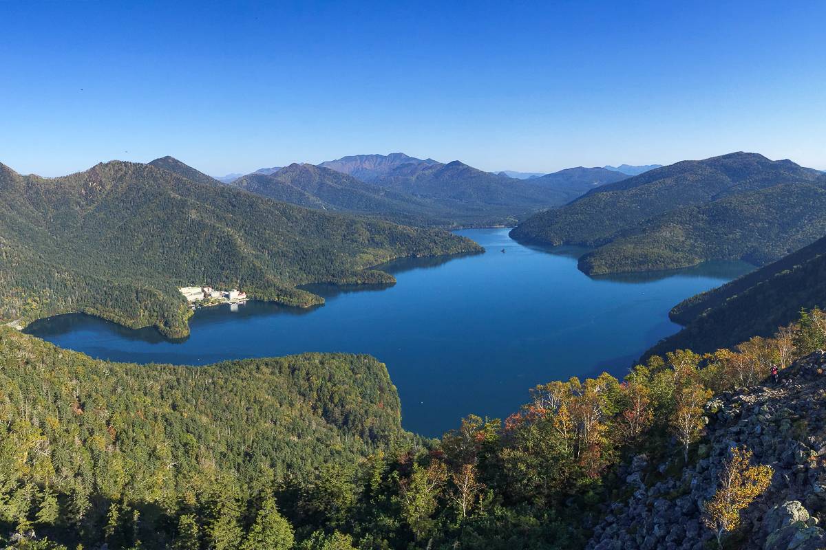
Passing over Hokkaido’s highest peak, Mount Asahi (2291m), the 13km traverse between Mount Asahi and Mount Kuro is a popular route across the roof of the Daisetsuzan Mountains.
With ropeway access at each end of the traverse, this hike maximises your time in the alpine. Between Mount Asahi and Mount Kuro (1984m) you traverse around Ohachidaira, an old volcanic crater, crossing many of Hokkaido's highest peaks along the way. The Ainu people call this area “Kamuy mintar”, or the playground of the gods.
While the hike is doable in a day, you can break up the traverse with a night at the Kurodake Refuge (Kurodake Ishimuro) either staying in the hut or camping outside.
What you will see on the Asahidake to Kurodake hike
- Mount Asahi (Asahidake), the highest peak in Hokkaido at 2291m.
- A vast alpine plateau formed by an old volcano.
Best time for hiking from Asahidake to Kurodake
The route is mostly clear of snow from late June to mid-October with July to August the best time to see the alpine flowers.
How to get to the Asahidake to Kurodake hike
The traverse can be done in either direction between the Asahidake Ropeway and the Kurodake Ropeway. There are buses from Asahikawa station to the Asahidake Ropeway and the Kurodake Ropeway in Sounkyo. The Kurodake Ropeway is also accessible by bus from Kamikawa station.
Handy locations for the Asahidake to Kurodake traverse hike
See our tour which includes the Asahidake to Kurodake hike
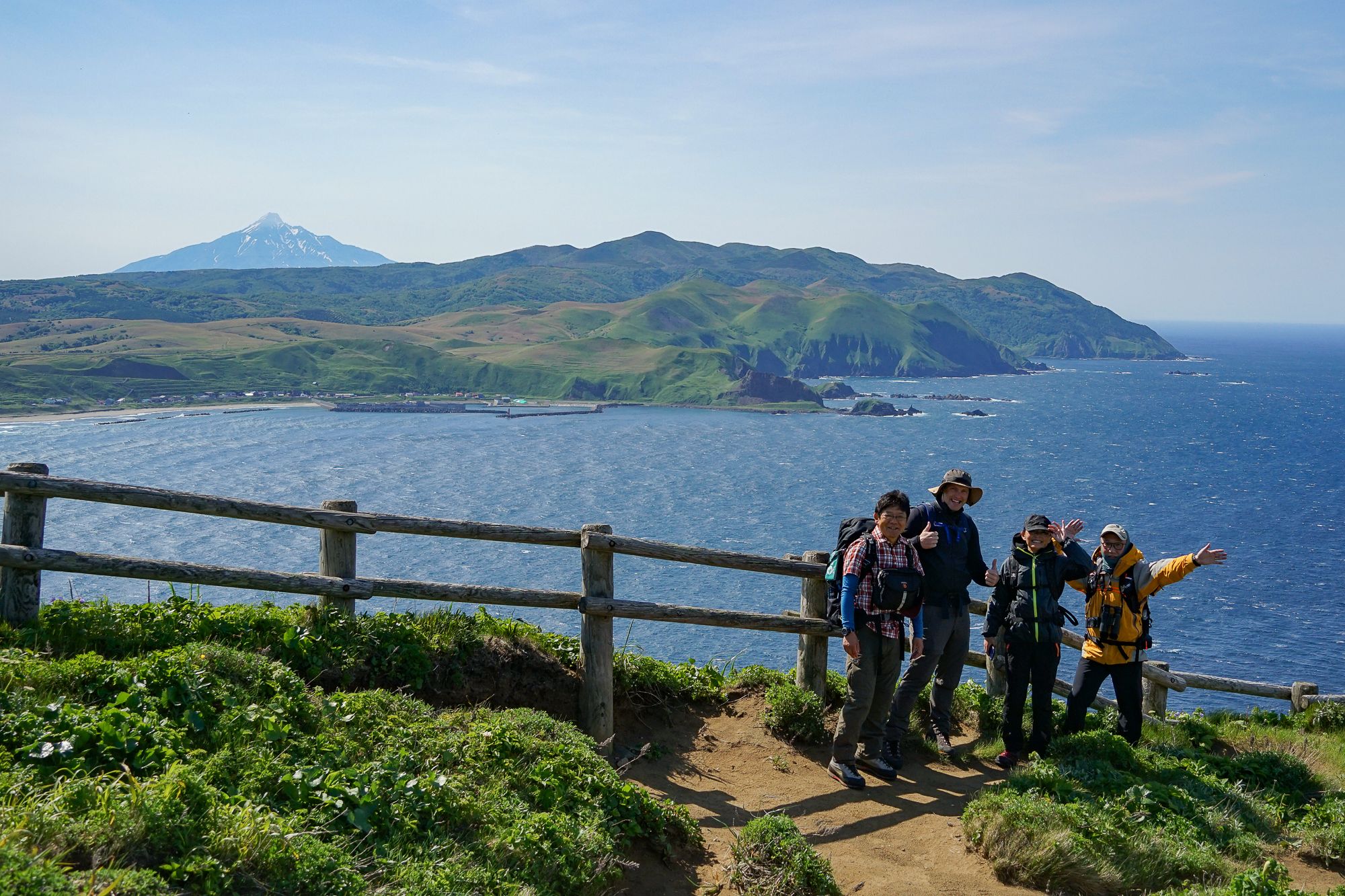
Misaki Meguri trail on Rebun Island #
- Time: Day hike / 5-6 hours
- Distance: 12km / 280m elevation gain
- Difficulty: 🥾🥾
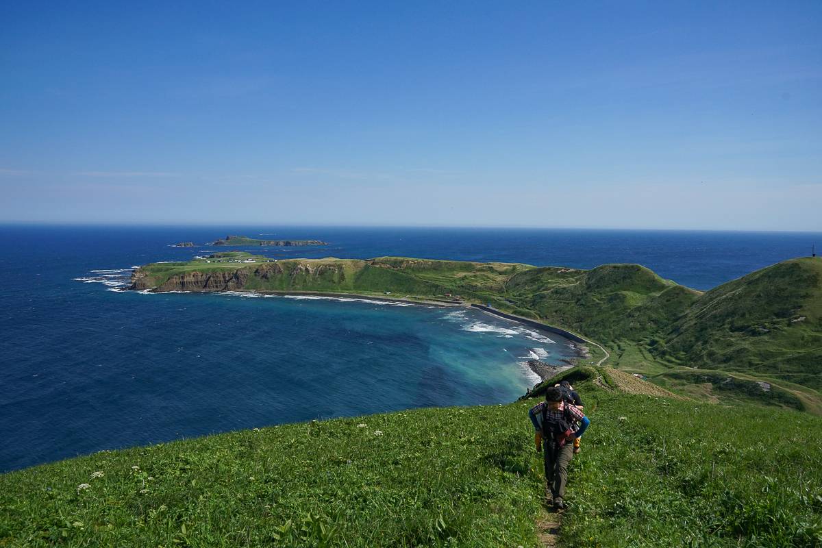
Starting from Cape Sukoton, the northernmost point of Rebun Island in the north of Hokkaido, the Misaki Meguri trail is closer to Russia than it is to Sapporo. Along the 12km long trail you walk along beach shores and over headlands covered in windswept low grass with 360 degree ocean views from the high point of the trail, Cape Gorota.
Part of the Rishiri-Rebun-Sarobetsu National Park, Rebun is known as the floating flower garden and the trail is dotted with flowers, including the rare cream orchid called the Rebun Atsumorisou or Rebun lady’s slipper orchid.
What you will see hiking the Misaki Meguri trail
- A rugged coastline with sea views across to Mount Rishiri-Fuji.
- Rebun lady’s slipper orchids, unique to Rebun with less than 20 plants flowering some years.
Best time for hiking the Misaki Meguri trail
There will often be snow cover until April, despite the low elevation. Many of the flowers bloom early in summer, while the Rebun lady’s slipper orchids only bloom in the first half of June.
How to get to the Misaki Meguri trail
Rebun lies 45km off the northern tip of Hokkaido. A ferry service from Wakkanai provides the only connection to the island. Buses to and from the ferry terminal stop at both ends of the trail, Cape Sukoton and Hamanaka.
Handy locations for the Misaki Meguri trail
Want to explore Japan's unique northern islands?
Check out our 7-day hiking tour to Rebun and Rishiri Islands
Mt Hakuunzan & Lake Shikaribetsu loop #
- Time: Half day / 3-4 hours
- Distance: 5km / 280m elevation gain
- Difficulty: 🥾🥾🥾
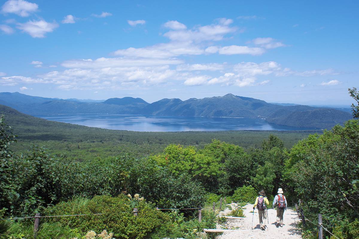
On the shore of Lake Shikaribetsu in the southern end of the Daisetsuzan National Park, Mount Hakuun (1186m) is surrounded by pine and birch forests. The summit has views over both the lake to the north and the Tokachi plains to the south and the rocky terrain is home to Nakiusagi (Northern pika). On the return leg, descend to the lake where another trail takes you along the lakeshore and back to the trailhead.
What you will see hiking the Hakuunzan to Lake Shikaribestu loop
- Lake Shikaribetsu, Hokkaido’s highest lake, and surrounding forest
- Northern pika scurrying between the rocks around the summit.
How to get to the loop
There is a bus service to the trailhead from Obihiro station, via Shintoku station, operated by Hokkaido Takusyoku Bus. Take #51 and get off at the Hakuunbashi stop (one before the final stop at Hotel Fusui). The bus takes around 1 hour 45 minutes.
Handy locations for hiking Mt Hakuunzan to Lake Shikaribetsu trail
Experience the majestic Mt. Hakuunzan for yourself!
Take a look at our Around Daisetsuzan 6 Day Hiking Tour, which includes this hike.
Mt Tarumae #
- Time: Half day / 3-4 hours
- Distance: 7km / 450m elevation gain
- Difficulty: 🥾🥾
Mount Tarumae (Tarumaezan) is a 1041m active stratovolcano on the rim of Lake Shikotsu in the Shikotsu-Toya National Park. The peak features a distinctive lava dome formed in an eruption in 1909.
The trail to the east peak (Higashiyama) is relatively easy and popular with all kinds of hikers, including kids from the local elementary school. While you can’t climb the lava dome (the gases are poisonous) you can loop around the crater rim to add 1 hour to the hike.
Mt. Tarumae is also a popular spot to see alpine flowers over the summer months and is included in the Hana-no-hyakumeizan, a list of 100 Japanese mountains famous for flowers.
What you will see hiking Mt Tarumae
- The characteristic steaming lava dome formed in the 1909 eruption.
- Views over Lake Shikotsu to the north and out to the Pacific Ocean to the south.
Best time for hiking Mt Tarumae
The alpine flowers bloom between mid-June and October, while the peak is snowbound from November to early May.
How to get to the Mt Tarumae hiking trail
Mount Tarumae is 1.5 hours southwest of Sapporo, but there is no public transport to the trailhead, so you will need your own vehicle. The trailhead is just off Route 141 on the eastern side of the mountain, but bear in mind this car park and road get busy on the weekend.
Handy locations for hiking Mt Tarumae
Join us for a hike up Mt. Tarumae
Our Shikotsu–Toya 5 Day Hiking Tour culminates with Mt. Tarumae, a perfect way to finish a hiking trip.
Daisetsu Kogen Numa #
- Time: Day hike / 5-6 hours
- Distance: 6.4km / 290m elevation gain
- Difficulty: 🥾🥾🥾
Situated between 1230m above sea level, Daisetsu Kogen Numa is nestled in the north east of the Daisetsuzan National Park, tucked away behind the main backbone of the range. This remote corner of the park is almost completely untouched by humans and is home to a great number of Hokkaido's Brown Bears, which are often spotted by hikers in the summer. If not the bears themselves, you'll very likely come across their huge paw prints on this route.
One of the charms of this hike is its adaptability. More experienced hikers will enjoy attempting the full loop, including its final and challenging climb down a stream! Intermediate hikers can turn back at the halfway point, while newer hikers can attempt the stretch as far as Midorinuma before returning to the trailhead.
Note that this hike is not open around the clock. The trail is managed by rangers, to protect hikers from unexpected bear encounters and bears from encountering human food. Therefore, the trail is only open between 07:00 - 15:00. They start the sweep from the high point around 13:00 and you will have to turn back if you meet a ranger on sweep. It's best to start the hike as early as you can if you'd like to complete the full loop at a leisurely pace!
What you will see hiking Daisetsu Kogen Numa
- Over a dozen beautiful alpine ponds scattered along the trail
- A dramatic alpine escarpment at the head of the valley that holds snow long into summer
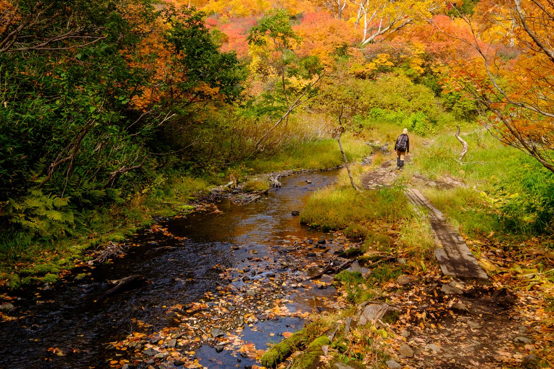
- Amazing autumn foliage in late September
- Glimpses of Hokkaido's wonderful wildlife - possibly even a Brown Bear!
Best time for hiking Daisetsu Kogen Numa
The trail is open from early June through to early-mid October. It is closed outside of this season. The autumn foliage season in late September is very beautiful and is a very popular season for Japanese hikers. However, this hike is beautiful in any season!
How to get to the Daisetsu Kogen Numa hiking trail
The trailhead is located at Daisetsu Kogen Onsen. You will have to sign in at the Higuma Centre and listen to a talk about bear safety before you are allowed through the gate. The talk is conducted in Japanese, but a presentation with English subtitles is also used.
Please note that Daisetsu Kogen Onsen is only accessible only by car (free parking). Note that the gravel road to Daisetsu Kogen Onsen is closed during the peak autumn foliage season, during which time a shuttle bus will operate from the Daisetsu Lake Camp Site, which serves as the shuttle bus stop during the peak season.
Handy locations for hiking Daisetsu Kogen Numa
Explore Daisetsu Kogen Numa with us
We visit this amazing route on both of our Daisetsuzan group hiking tours!
Mt Meakan loop via Lake Onneto #
- Time: Day hike / 5-6 hours
- Distance: 9.9km / 1030m elevation gain
- Difficulty: 🥾🥾🥾🥾
Mount Meakan (1499m) is an active volcano in the Akan-Mashu National Park in eastern Hokkaido. It is featured in both the Hyakumeizan (100 famous mountains) and Hana-no-hyakumeizan (100 mountains famous for flowers) lists, making it a popular destination for Japanese hikers.
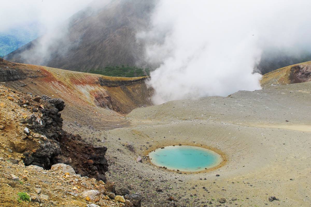
The trail climbs out of the pine forest and up to the rocky crater rim before topping out at the summit. From the summit, continue around the crater then descend to Lake Onneto via the saddle between Mount Meakan and Mount Akan-fuji. Despite appearing barren, the rocky upper mountain is home to many alpine flowers and some, such as the Meakan-fusuma, were first discovered on the mountain.
What you will see hiking the Mt Meakan loop
- Smoke rising from the crater of an active volcano.
- Rare alpine flowers.
- Views over Lake Akan and the neighbouring peak of Mt Akan-Fuji
Best time for hiking the Mt Meakan loop
The peak is clear of snow earlier than those in the Daisetsuzan range, usually from the start of June through to late October. The alpine flowers reach their peak between mid-June and July.
How to get to the Mt Meakan trail
Mount Meakan in eastern Hokkaido near Lake Akan, a popular tourist spot. There are bus services to Lake Akan but there is no public transport to the trailhead. For those with your own car, the trailhead is on a side road (#949) off Route 241, 16km from Lake Akan town.
Handy locations for hiking the Mt Meakan loop
Maruyama, Sapporo #
- Time: Half day / 2 hours
- Distance: 2.6km / 250m elevation gain
- Difficulty: 🥾
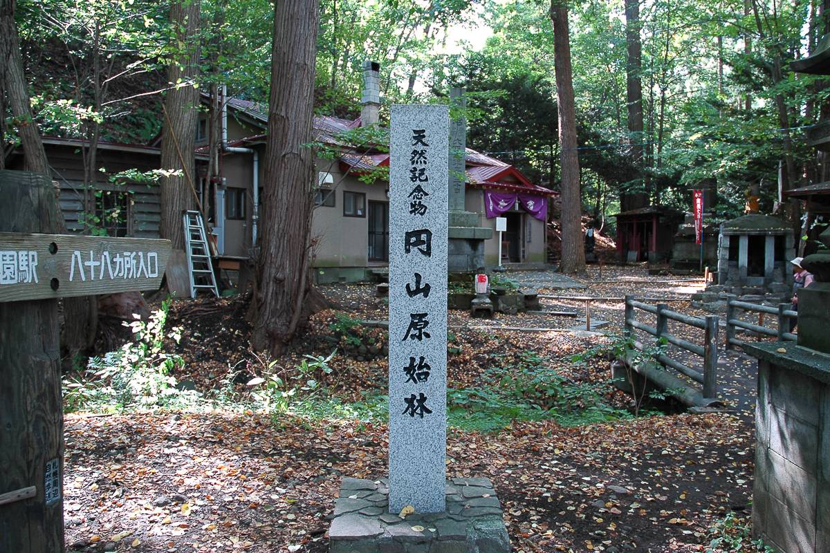
Just 30 minutes from the centre of Sapporo, Hokkaido’s largest city, Maruyama and the surrounding park is popular with locals escaping the bustle of the city.
From the park, an easy 1-hour hike takes you to the peak of Maruyama at 200m where you can look back over the city. The Hachijuhachi-ka-sho route is the pick of the two trails, starting only 15 minutes from the Maruyama Koen subway station and lined with old Buddhist statues. Both routes can also be combined as a traverse returning through the park.
What you will see hiking at Maruyama
- City views flanked by green woodland
- Friendly chipmunks
- Buddhist Jizo stone statues
Best time for hiking Maruyama
The sakura (Cherry blossom) trees in the park blossom in late-April to mid-May, while the trees around Maruyama turn orange in late October. The trail does get buried in snow during winter, but that doesn’t stop the local hikers.
How to get to the Maruyama trail
The Maruyama Koen station is a 30 minute subway ride from Sapporo station, changing to the Tozai Line at Odori station. From the station it is a 15 minute walk through the park to the start of the Hachijuhachi-ka-sho route. The Hokkaido Shrine is also 15 minutes from the station.
Handy locations for hiking Maruyama
Traverse from Mt Okura to Mt Sankaku #
- Time: Half day / 1 hour
- Distance: 1.8km / 150m elevation gain
- Difficulty: 🥾
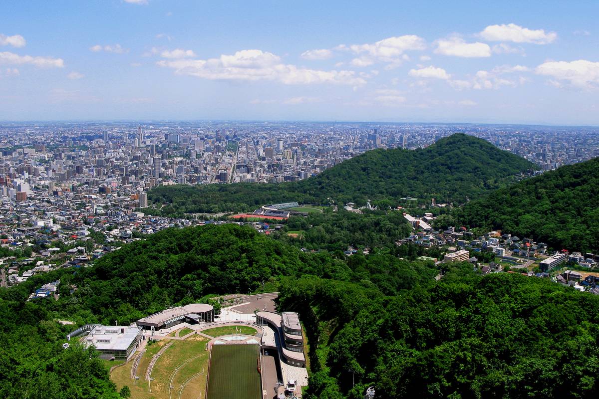
Mount Okura hosted the ski jump event during the 1972 Sapporo winter olympics and the hike starts with a chairlift ride at the jump stadium. The jump is still used for training in both summer and winter and you will often see athletes training from the lift.
From the Okurayama Lookout at the top of the lift an easy 900m trail through the trees leads to the summit of Mount Sankaku (310m) with benches and city views. From Mount Sankaku you can either return to the lift at Okurayama or continue down the trail to the Yama-no-te trailhead and catch a bus back to the station.
What you will see hiking from Mt Okura to Mt Sankaku
- The ski jump from the 1972 Sapporo winter olympics that is still used for training.
- Views of Sapporo city sprawling out below you.
Best time for hiking the Mt Okura to Mt Sankaku trail
The trail is clear of snow from April to November although local’s do the hike all through winter. The lift runs until 9pm in the summer season and timing your hike to finish around sunset lets you see the city light up.
How to get to the Mt Okura trail
Okurayama is in western Sapporo and on the Kuramaru bus line. The bus departs every 30 minutes from platform 4 of the Maruyama bus terminal. To get to the bus terminal from the city center you take a 30 minute subway ride to Maruyama Koen station on the Tozai line.
Handy locations for hiking Mt Okurayama to Mt Sankakuyama
Mt Apoidake #
- Time: Half day / 4-5 hours
- Distance: 8.5km / 800m elevation gain
- Difficulty: 🥾🥾🥾
Mount Apoi (810m) and its surrounding area are a Unesco Global Geopark. The peak is formed from peridotite, rock thrust up from the Earth’s mantle, and you can find the green rock across the mountain. Due to the unique geology and environment, the mountain is home to flora and fauna not found anywhere else, such as the Himechamadara Seseri butterfly and a white buttercup called Hidaka-sō.
The 4.3km trail to the summit climbs along the western ridge known locally as Umanose, or horse’s back. Despite the low elevation, the upper mountain is clear of trees giving unobstructed views over the Pacific Ocean.
What you will see hiking Mt Apoi
- Rocks formed from the earth’s mantle.
- Alpine scenery a stone’s throw from the Pacific ocean.
- Flora and fauna found nowhere else on earth.
Best time for hiking Mt Apoi
Mount Apoi gets less snow than many of Hokkaido’s mountains and the route is usually clear of snow from April – November. The flowers bloom from May to September while the Himechamadara Seseri butterflies can be seen from mid May to mid June.
How to get to the Mt Apoi trail
Mount Apoi is in the Hidaka region, 3½ to 4 hours south east of Sapporo. There are bus services to the trailhead, with a direct bus from Sapporo leaving every afternoon. For more flexible bus options it is necessary to change enroute, the visitor centre has information on all the routes in English.
Handy locations for hiking Mt Apoi
There’s a hike for everyone in Hokkaido
The trails mentioned in this blog post are just a sample of the amazing hiking on offer in Hokkaido and hopefully they have inspired you to lace up your boots and hit the trail.
Hokkaido is a unique place and sometimes hard to unpack for visitors. At Adventure Hokkaido we pride ourselves in giving you the locals insight to our home island. We have designed our Hokkaido Hiking Tours to allow you to experience the best of Hokkaido’s wild landscape whilst removing the barriers found when travelling in an unfamiliar land.
Ready to find out more?
See our Hokkaido hiking, cycling & nature tours